NCS Map and County Committees
NCS Map and County Committees
NCS Map and County Committees
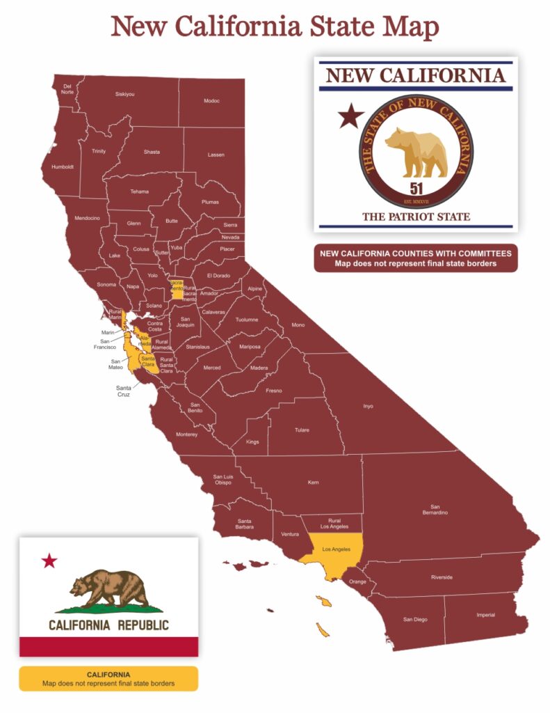
Proposed State of New California Map
New California State is based on the rural areas of California becoming New California. The map as it stands now is representative of the active county committees who are involved in New California. When we release the final map there will be contiguous borders for both New California State and California. What it will reveal are two states with populations that are near equal but based on rural vs urban populations. New California will NOT include the most densely populated areas of California.

New California State Map [PDF]
New California State is based on the rural areas of California becoming New California State. The map as it stands now is representative of the active county committees who are involved in New California State. When we release the final map there will be contiguous borders for New California State and not for California. What it will reveal are two states with populations which are near equal but based on rural vs urban populations.
New California State will NOT include the most densely populated areas of California. As an example the most densely populated area of Santa Clara County will not be a part of New California. The same with Sacramento, Los Angles and Alameda counties. These counties carry the designation on the map as “Rural” because their large urban areas would throw off the rural population density of New California State we are attempting to achieve in order to attain real representation by our New California State elected public servants.
Note the assembly district map of California to see the heavy concentration of Assembly Members in the Los Angeles county area that will not be a part of New California State.
When you take a closer look at both the federal and state numbers of representatives the lack of representation for rural California becomes even more evident. Here are the numbers of representatives for California both federal and state for 2017-2018.
Federal
As of 2022
Senate 2
House of Representatives 52
Federal Party Affiliations
Senate 2 Democrats
House 40 Democrats, 12 Republicans
State
As of 2022
Senate 40
State Assembly 80
State of California Party Affiliations
Senate 32 Democrats, 8 Republicans
Assembly 62 Democrats, 18 Republicans
NEW CALIFORNIA STATE 56 COUNTIES JULY 4, 2018
Alameda (R)
Contact: Danamarie Greer
Chair & State Senator
Senator New California
Phone: (887) 828-2253
E-mail:
newcaliforniastaterepublic@gmail.com
Alpine
Contact: Russ Wyluda
Chair & Senator
Phone: (310) 486-4925
E-mail:
newcaliforniastaterepublic@gmail.com
Amador
Contact: Louis McDonald
Chair & State Senator
Phone: (877) 828-2753
E-mail:
newcaliforniastaterepublic@gmail.com
Butte
Contact: Bryant Hart
Chair
Phone 1: (530) 902-5233
Phone 2: (877) 828-2753
E-mail: NCS51@usa.com
Contact: Michael Kehoe
State Senator
Phone: (530) 514-1792
Calaveras
Contact: Terry McBride
Chair & Senator
Phone: (877) 828-2753
E-mail:
newcaliforniastaterepublic@gmail.com
Colusa
Contact: Tina Hessong
Chair & Senator
Phone: (877) 828-2753
E-mail: thessong51@proton.me
Contra Costa
Contact: Liz Richie
Chair & Senator Member
Phone:(925) 699-7962
E-mail:
newcaliforniastate51@gmail.com
Del Norte
Contact: Barre Lando
Chair & Senator
Phone: (877) 828-2753
E-mail:
newcaliforniastaterepublic@gmail.com
El Dorado
Contact: Roger Luzada
Chair & Senator
Phone 1: (530) 417-1870
Phone 2: (877) 828-2753
E-mail: RogerLuzada_NCS51@protonmail.com
Fresno
Contact: Randy Shahbazian
CHAIR & State Senator
Phone 1: (559)250-3521
Phone 2: (877) 828-2753
E-mail: randy1776@protonmail.com
Glenn
Contact: Merry Lervold
Chair & Senator
Phone: (877) 828-2753
E-mail: merrylynne@outlook.com
Humboldt
Contact: John Damon
Chair & Senator
Phone: (877) 828-2753
E-mail: newcaliforniastaterepublic@gmail.com
Imperial
Contact: David Garrison
Chair & Senator
Phone: (877) 828-2753
E-mail: newcaliforniastaterepublic@gmail.com
Inyo
Contact: Robert Olin
Chair & Senator
Phone 1: (760) 254-3046
Phone 2: (877) 828-2753
E-mail: robert.olin64@icloud.com
Kern
Contact: Jim Robinson
Chairman Assembly
Contact: Cameron Lorimer
Senator
Phone: (877) 828-2753
E-mail: jrtroubador@gmail.com
Kings
Contact: Elin Carlson
Chairman & Senator
Phone: (877) 828-2753
E-mail: newcaliforniastaterepublic@gmail.com
Lake
Contact: John Lord
Chairman
Phone: (877) 828-2753
E-mail: newcaliforniastaterepublic@gmail.com
Lassen
Contact: Howard Thomas
Chair & Senator
Phone: (877) 828-2753
E-mail: newcaliforniastaterepublic@gmail.com
Los Angeles
Contact: Austin Wright
Chair & Senator
Phone 1: (661) 955-2999
Phone 2: (877) 828-2753
E-mail: a.wright_ncs51@protonmail.com
Madera
Contact: Kimmy Fox
Chair & Assembly
Senator (TBA)
Phone: (877) 828-2753
E-mail: newcaliforniastaterepublic@gmail.com
Mariposa
Contact: Tasso Koken
Chair & Senator
Phone: (877) 828-2753
E-mail: newcaliforniastaterepublic@gmail.com
Marin (R)
Contact: Donna Pfeiff
Chair & Senator
Phone: (415) 305- 8240
E-mail: djpfeiff@msn.com
Mendocino
Contact: Coleen Browder
Chair & Senator
Phone: (707) 542-5211
E-mail: coleenb@sonic.net
Merced
Contact: Don Catudal
Chair & Senator
Phone: (877) 828-2753
E-mail: catudal@me.com
Marin (R)
Contact: Donna Pfeiff
Chair & Senator
Phone: (415) 305- 8240
E-mail: djpfeiff@msn.com
Mendocino
Contact: Coleen Browder
Chair & Senator
Phone: (707) 542-5211
E-mail: coleenb@sonic.net
Merced
Contact: Don Catudal
Chair & Senator
Phone: (877) 828-2753
E-mail: catudal@me.com
Modoc
Contact: Noelle Jones
Chair & Senator
Phone: (530) 233-8173
E-mail: jnjones42@gmail.com
Mono
Contact: Tesla Gaylon
Chair & Senator
Phone: (877) 828-2753
E-mail : newcaliforniastaterepublic@gmail.com
Monterey
Contact: Angie Morfin
Chair & Senator
Phone: (877) 828-2753
E-mail: newcaliforniastaterepublic@gmail.com
Napa
Contact: Paul Preston
NCS
Phone: (877) 828-2753
E-mail: newcaliforniastaterepublic@gmail.com
Nevada
Contact: Carolyn Burk
Chair & Senator
Phone: (877) 828-2753
E-mail: newcaliforniastaterepublic@gmail.com
Orange
Contact: Roseann DiCostanzo
Chair & Senator
Phone: (877) 828)-2753
E-mail: NCS.OC@proton.me
Placer
Contact: Russ Wyluda
Phone: (310) 486-4925
Assembly
Contact: Doug Wells
Assembly
Contact: Dr. Dan Anderson
Senator
E-mail: newcaliforniastaterepublic@gmail.com
Plumas
Contact: Howard Thomas
Chair & Senator
Phone: (530) 228-5434
E-mail: hthomas10@gmail.com
Riverside
Contact: Shelby Bunch
Chair & Senator
Phone 1: (951) 284-9412
Phone 2: (877) 828-2753
E-mail 1: RIV-NCS@proton.me
E-mail 2: star@ncs51.com
Sacramento (R)
Contact: Sarah Mattson
Chair & Assembly
Phone: (877) 828-2753
E-mail: NCS51-RuralSAC@pm.me
San Benito
Contact: Joshua Disney
Chair & Senator
Phone: (877) 828-2753
E-mail: jadman14@hotmail.com
San Bernardino
Contact: Joanne Igyarto
Chair & Senator / Assembly
Phone: (877) 828-2753
E-mail: joanneigyarto@gmail.com
San Diego
Contact: Kate Kornas
Chair & Senator
Phone: (858) 776-2531
E-mail: sdnewcaliforniastate51@gmail.com
San Joaquin
Contact: Aram Alexander
Chair & Assembly
Phone: (209) 649-4204
E-mail 1: Aram@newcali51.com
E-mail 2: newcaliforniastaterepublic@gmail.com
San Luis Obispo
Contact: Linda Quinlan
Chair & Assembly / Senator
Phone: (805) 441-4842
E-mail 1: Quilm8@aol.com
E-mail 2: newcaliforniastaterepublic@gmail.com
Santa Barbara
Contact: LeAnne Woolever
Chair & Senator
Phone: (877) 828-2753
E-mail: ncs.sb.county@gmail.com
Santa Clara (R)
Contact: Charlotte Thornton
C0-Chair & Senator
Phone: (408) 771-7334
E-mail: maglev@stanford.edu
Santa Cruz
Contact: Sandy Schmidt
Chair & Senator
Phone 1: (408) 410-9321
Phone 2: (877) 828-2753
E-mail: sandycoach@protonmail.com
Shasta
Contact: Patty Plumb
Chair Shasta County, Assembly
Contact: Ron Plumb
Senator
Phone: (530) 710-3555
E-mail: pattyplumb@yahoo.com
Sierra
Contact: Howard Thomas
Chair & Senator
Phone: (530) 632-9786
E-mail 1: hthomas10@gmail.com
E-mail 2: newcaliforniastaterepublic@gmail.com
Siskiyou
Contact: Johnna Brooks
Chair & State Senator
Phone: (877) 828-2753
E-mail: johnna.newcaliforniastate51@yahoo.com
Solano
Contact: Rick Fowler
Chair & Senator
Phone: (707) 330-8445
Phone: (877) 828-2753
E-mail: rfvaca@gmail.com
Sonoma
Contact: Frank Warren
Chair & Senator
Phone: (877) 828-2753
E-mail 1: franklin.c@gmail.com
E-mail 2: newcaliforniastaterepublic@gmail.com
Stanislaus
Contact: Mylinda Mason
Chair & Senator
Phone: (877) 828-2753
E-mail: mmisapatriot@gmail.com
Sutter
Contact: Paul Preston, Chairman
President New California State
Senator Lavern Denyer
Phone: (530) 632-9786
E-mail: newcaliforniastaterepublic@gmail.com
Tehema
Contact: Martha Scheeler
Chair & Senator
Phone: (877) 828-2753
Trinity
Contact: Vickey Whaley
Chair & Senator
Phone: (530) 227-2582
E-mail: vicki.whaley@gmail.com
Tulare
Contact: Cindy Porras
Chair & Senator
Phone: (530) 632-9786
E-mail: info@eclecticevents.us
Tuolumne
Contact: Michelle O’Connor
Chair & Senator
Phone: (877) 828-2753
E-mail: kemosean@yahoo.com
Ventura
Contact: Deb Morgan
Phone 1: (805) 290-0828
Phone 2: (877) 828-2753
E-mail: newcaliforniastaterepublic@gmail.com
Yolo
Contact: Thomas Jones
Chair & Senator
Contact: James Salamon
Assembly
Phone: (877) 828-2753
E-mail: newcaliforniastaterepublic@gmail.com
Yuba
Contact: Robert Armstong
Chair
Phone: (530) 906-7738
E-mail 1: robconca@protonmail.com
E-mail 2: newcaliforniastaterepublic@gmail.com
Yolo
Contact: Thomas Jones
Chair & Senator
Contact: James Salamon
Assembly
Phone: (877) 828-2753
E-mail: newcaliforniastaterepublic@gmail.com
Yuba
Contact: Robert Armstong
Chair
Phone: (530) 906-7738
E-mail 1: robconca@protonmail.com
E-mail 2: newcaliforniastaterepublic@gmail.com
Next Steps
Join New California State and become a Member to receive email updates:
Help New California State meet its financial obligations – donate today:

